Trinity Villas

Trinity Villas

Trinity Villas (Плака,Греция)

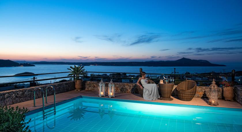
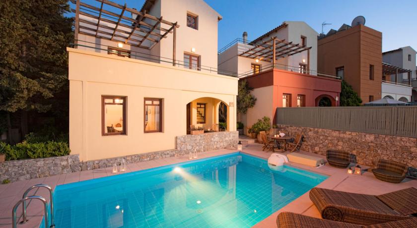
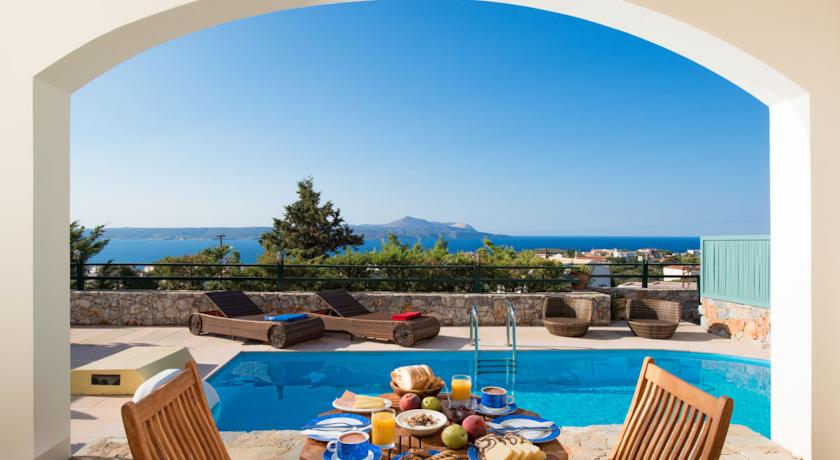
Категория отеля:
Адрес: Plaka, Плака, 73007, Греция
Описание: Комплекс современных вилл Trinity находится в поселке Плака. С их территории открывается панорамный вид на Критское море. К услугам гостей частный бассейн с солнечной террасой и шезлонгами, а также бесплатный WiFi на всей территории.Все виллы оформлены в теплых тонах и располагают меблированным патио и балконом. Потолок отделан деревянными балками. Гостиная с камином оборудована телевизором со спутниковыми каналами. На полностью укомплектованной кухне установлен обеденный стол. В ванной комнате в вашем распоряжении гидромассажная ванна. В числе прочих удобств – кондиционер и стиральная машина.На территории вилл Trinity имеются принадлежности для барбекю. В радиусе около 500 метров можно посетить различные таверны, продуктовые магазины и снэк-бары.Расстояние до международного аэропорта Ханьи составляет приблизительно 20 км. Регион отлично подходит для активного отдыха, в частности катания на водных лыжах, а также занятий дайвингом и виндсерфингом. На территории обустроена бесплатная парковка.
Еда и питье:
На свежем воздухе: Барбекю , Сад, Терраса для загара
Парковка: Бесплатно! Бесплатная Общественная парковка на месте (предварительный заказ не требуется) .
Услуги:
Спорт и отдых:
Сервис:
Интернет: Бесплатно! Wi-Fi предоставляется на территории всего отеля бесплатно.
Языки общения: на английском, на греческом
Время заезда/выезда: 14:00 - 20:00 / 07:00 - 12:00
Домашние животные: Размещение домашних животных допускается по предварительному запросу. Данная услуга может быть платной.
Банковские карты:
Номерной фонд: Вилл: 5
Координаты: ш. 35.4496932867972 д. 24.211206436157227 на карте
 

Каталог отелей.

Игры ⚽ Поможем написать курсовую

Полезное


Смотреть что такое "Trinity Villas" в других словарях:

  • Newhaven —    NEWHAVEN, a sea bathing village, and lately a quoad sacra parish, in the parish of North Leith, county of Edinburgh, 1 mile (W. by N.) from Leith, and 2 (N.) from Edinburgh; containing 2103 inhabitants. This place derives its name, in… …   A Topographical dictionary of Scotland

  • List of places of worship in Brighton and Hove — St Peter s Church is the parish church of Brighton Map of al …   Wikipedia

  • Western architecture — Introduction       history of Western architecture from prehistoric Mediterranean cultures to the present.       The history of Western architecture is marked by a series of new solutions to structural problems. During the period from the… …   Universalium

  • Stroud Green, London — infobox UK place country = England map type = Greater London region= London population= official name= Stroud Green constituency westminster= post town= LONDON postcode area=N postcode district=N4 london borough= Haringey dial code= 020 os grid… …   Wikipedia

  • Historia de los vascos — Lauburu, un símbolo de la cornisa cantábrica. La historia de los vascos, trata sobre la historia del pueblo de origen no indoeuropeo[1] actualmente asentado en el sudoeste de Francia y el norte de España, en las actuales Comunidad Autónoma Vasca… …   Wikipedia Español

  • United Kingdom — a kingdom in NW Europe, consisting of Great Britain and Northern Ireland: formerly comprising Great Britain and Ireland 1801 1922. 58,610,182; 94,242 sq. mi. (244,100 sq. km). Cap.: London. Abbr.: U.K. Official name, United Kingdom of Great… …   Universalium

  • Malvern, Worcestershire — Coordinates: 52°06′29″N 2°19′30″W / 52.108°N 2.325°W / 52.108; 2.325 …   Wikipedia

  • Edinburgh —    EDINBURGH, a city, the seat of a university, and the metropolis of the kingdom of Scotland, situated in longitude 3° 10 30 (W.), and latitude 55° 57 29 (N.), about a mile (S. by W.) from Leith, 40 miles (S.S.W.) from Dundee, 42 (E. by N.) from …   A Topographical dictionary of Scotland

  • Listed buildings in Liverpool — Partial and incomplete lists of listed buildings in Liverpool, England. A *July 28 1952 II Abercromby Square L7 Garden House *July 28 1952 II Abercromby Square (west side) L7 Nos. 1 to 7 (consec) No. 7a *July 28 1952 II Abercromby Square (south… …   Wikipedia

  • Tulse Hill — infobox UK place country = England map type = Greater London region= London population= official name= Tulse Hill london borough= Lambeth constituency westminster= Dulwich and West Norwood post town= LONDON postcode area=SE postcode district=… …   Wikipedia


Поделиться ссылкой на выделенное

Прямая ссылка:
Нажмите правой клавишей мыши и выберите «Копировать ссылку»